


Good street design begins with an understanding of the street context. Different streets have different conditions, and merit differing design considerations. When considering design improvements to a street, the project sponsor should start by identifying the street type, and designing features appropriate to it.
The San Francisco Better Streets Plan establishes a set of street types for the city’s street system. Street types are defined by land use context and transportation characteristics. Other special conditions are called out individually.
San Francisco Street Types Map
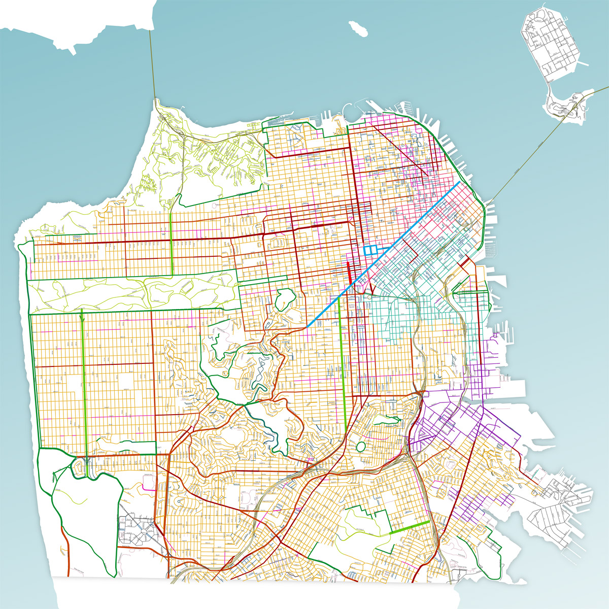
Click above to download a PDF of the Better Streets Plan Street Typology Map (36″ x 48″ – 1 MB)
These street types are not intended to replace official functional transportation classifications (shown in the Transportation Element of the San Francisco General Plan) but instead are meant to serve as a guide for designing appropriate streetscape environments.
The Better Streets Plan establishes the following street types:
Commercial
Residential
Industrial/Mixed-use
Special
- Parkways
- Park Edge Streets
- Park Interior (coming soon)
- Multi-way Boulevards
- Ceremonial (Civic) Streets
- Alleys
- Shared Public Ways
- Paseos (Pedestrian-Only Streets)
Determining Street Type
Land Use Context
Land-use context for a given block is determined by the zoning class of the adjacent parcels, per the following table:
| STREET TYPE | ZONING DISTRICT ( PER SF PLANNING CODE ) | |
|---|---|---|
| COMMERCIAL | Downtown | C-3, C-2 (C-3 adjacent), CCB (w/in Downtown Streetscape Plan) |
| Throughway, Neighborhood | NC, C-2, NCT, CCB (not w/in Downtown Streetscape Plan), CVR, CRNC, MB Retail, MB Hotel | |
| RESIDENTIAL | Downtown | DTR, RC-3, RC-4 |
| Throughway, Neighborhood RH | RH, RM, RTO, RED, MB Residential | |
| OTHER | Industrial | C-M, M1, M2, PDR-1, PDR-1-B, PDR-1-G (except Transit-Oriented Retail SUD), PDR-2 |
| Mixed-use | MUG, MUO, MUR, PDR-1-D, PDR-1-G (Transit-Oriented Retail SUD only), SLR, SLI, SPD, SSO, RSD, UMU, MB districts: Public Facilities, Commercial Industrial, Commercial Industrial/Retail | |
Transportation Context
Throughway streets carry greater volumes and higher speeds of vehicle traffic, while neighborhood streets have lower speeds and volumes. Throughway streets (both residential and commercial) include streets identified in the San Francisco General Plan Transportation Element Map 6: Vehicular Streets as “Major Arterial,” “Transit Conflict Street,” or “Secondary Arterial.” Neighborhood streets (both residential and commercial) are those streets not identified as such.
Special Conditions
Parkways: Parkways are streets with significant planted areas (generally greater than 15 to 20′ wide) that may be used as open space, either in the medians or edges of the roadway.
Example: Dolores, Park Presidio
Park Edge Streets: Park edge streets are located along the edges of major city parks, such as Golden Gate Park, McLaren Park, or portions of the waterfront. Park edge streets have open space on one side and development on the other side, with a pattern that continues for several blocks at least.
Example: Fulton Street
Park Interior Streets: Park interior streets are located entirely within city parks and open spaces. The City has not yet developed guidelines for park interior streets.
Example: John F. Kennedy Drive
Boulevards: Boulevards are streets that separate through traffic from local access by medians.
Example: Octavia Boulevard
Ceremonial (Civic) Streets: Ceremonial streets are grand civic spaces which serve as major gathering spots and serve as well-known public spaces and attractions. Ceremonial Streets are unique, and there are limited examples in the city.
Example: Market Street
Alleys: An alley is a public right-of-way less than 40 feet in width that is also a secondary network within the street hierarchy.
Shared Public Ways: Shared public ways are streets designed at a single-surface that share space among pedestrians, bicycles, and vehicles.
Example: Linden Alley
Paseos (pedestrian-only streets): Paseos are pedestrian-only streets that are either permanently or intermittently closed to motorized vehicles.
Examples: Ecker Street, Belden Lane
Notes
For all street types, designers should consider additional special roles a street may play, such as importance as a transit corridor, or having particular ecological significance.
In some cases, the point of a project may be to change the function of a street, for example from a major throughway to a traffic-calmed street, or an alley to a shared public way. The ultimate role for the street should be used when designing improvements.
An individual street may fit into one or more street types. Consecutive blocks of a street may fall into different street types where land use, context, and function of the street shift. Designs may shift accordingly.
Multiple zoning districts may exist on the same block or be scattered across the area. Or, a street may form the boundary between two districts of differing character. In these cases, the designer should consider the predominant character of the area to determine appropriate streetscape design. The designer should consider the goals of the project and the needs of existing and potential future land uses when deciding on the appropriate design, and create a consistent streetscape design for the corridor.
Gateways and Transitions
Locations where different street types intersect may warrant special design treatments. For example, where neighborhood residential streets intersect with major throughways, a gateway treatment such as a planted median island or other traffic calming feature may be appropriate. Similarly, where freeway on and off ramps intersect with city streets, there may be a need to highlight this transition to alert drivers to the fact that they are entering a surface street where pedestrians are likely to be present.